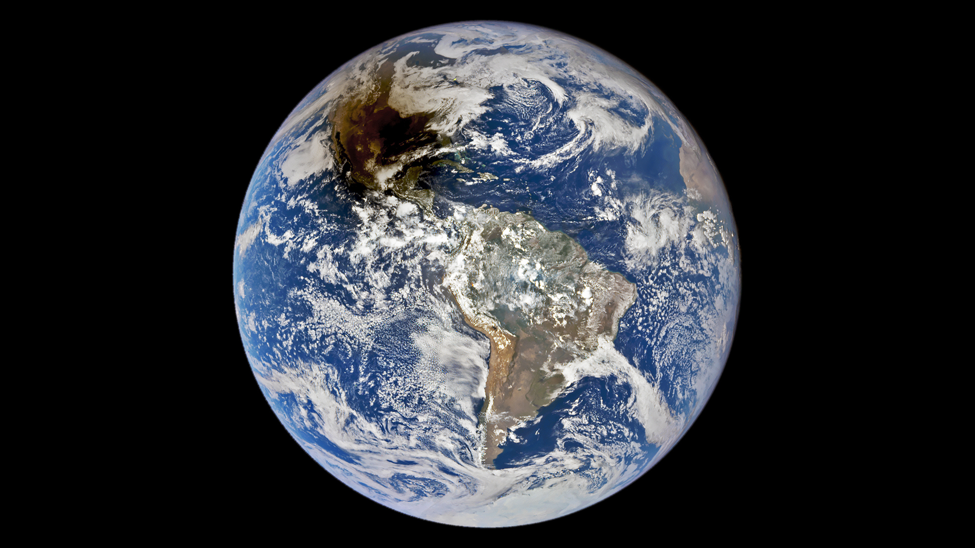

The recent “ring of fire” solar eclipse looked stunning across portions of North and South America and we now have a new view of the stellar event. The Deep Space Climate Observatory (DSCOVR) satellite created the image of the eclipse on Saturday October 14, depicting the mostly blue Earth against the darkness of space, with one large patch of the planet in the shadow of the moon.
[Related: Why NASA will launch rockets to study the eclipse.]
Launched in 2015, DSCOVR is a joint NASA, NOAA, and U.S. Air Force satellite. It offers a unique perspective since it is close to 1 million miles away from Earth and sits in a gravitationally stable point between the Earth and the sun called Lagrange Point 1. DSCOVR’s primary job is to monitor the solar wind in an effort to improve space weather forecasts.
A special device aboard the satellite called the Earth Polychromatic Imaging Camera (EPIC) imager took this view of the eclipse from space. According to NASA, the sensor gives scientists frequent views of the Earth. The moon’s shadow, or umbra, is falling across the southeastern coast of Texas, near Corpus Christi.
An annular solar eclipse occurs when the moon moves between Earth and the sun. The sun does not vanish completely in this kind of eclipse. Instead, the moon is positioned far enough from Earth to keep the bright edges of the sun visible. This is what causes the “ring of fire,” as if the moon has been outlined with bright paint.

While this year’s event could be seen to some degree across the continental United States, the 125-mile-wide path of annularity began in Oregon around 9:13 AM Pacific Daylight Time. The moon’s shadow then moved southeast across Nevada, Utah, Arizona, Colorado, and New Mexico, before passing over Texas and the Gulf of Mexico. It continued south towards Mexico’s Yucatan, Peninsula, Belize, Honduras, Nicaragua, Costa Rica, Panama, Colombia, and Brazil
Unlike the colorful Aurora Borealis, eclipses are much easier to predict. Scientists can say when annular and solar eclipses will happen down to the second centuries in advance. The precise positions of the moon and the sun and how they shift over time is already known, so scientists can see how the moon’s shadow will fall onto Earth’s globe. Advances in computer technology have also enabled scientists to even chart eclipse paths down to a range of a few feet.
[Related: We can predict solar eclipses to the second. Here’s how.]
The next annular solar eclipse will be at least partially visible from South America on October 2,2024. One of these ‘ring of fire’ eclipses will not be visible in the United States until June 21, 2039. However, a total solar eclipse will darken the sky from Maine to Texas on April 8, 2024. There is still plenty of time to get eclipse glasses or make a pinhole camera to safely watch the next big celestial event.
